The Luxembourg Institute of Science and Technology (LIST) has published an analysis of the spring weather experience in Luxembourg which has been achieved as part of work conducted on research projects in collaboration with the Administration des Services Techniques de l'Agriculture (ASTA) and MétéoLux.
The spring of 2016 in Luxembourg was colder than average, and the abundant rain in late May ensured that almost everywhere across the Grand Duchy ended the month with more precipitation (rainfall) than average.
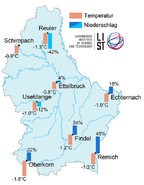
Meteorological Situation
The spring of 2016 was marked by the alternation of high and low pressure areas. This led alternately to mild and cold air in Luxembourg with typical April weather. Unlike previous years, there were repeated occurrences of massive cold air. In particular, air masses of polar origin returned at the end of April which significantly affected temperatures within a short time, which rose again the following week under the influence of sub-tropical air masses. On the last weekend of May, the storm risk increased with the arrival of warm humid air masses. This led to, on 30 May, especially in the south of the country, to heavy precipitation (see Hot Topic below).
Temperature
In the spring of 2016, average temperatures of the season were recorded at all stations in Luxembourg which were below those of the comparative period 2001-2010. The slightest deviation was measured at -0.8°C at the weather station in Ettelbrück, while the highest deviation was registered at -1.8°C by the weather station in Oberkorn. The weather station at Findel recorded tenperatures that were below the average for 2001-2010 for all three months. On the last weekend in April, the average daily temperatures decreased to 1.5°C. Compared to the reference period 1981-2010 in May at the weather station in Findel, however, it was warmer by 0.4°C.
Precipitation
The measured precipitation totals in the spring of 2016 showed suststantial variations, with the weater stations at Reuler (-42%) and Useldange (-12%) the only ones to show less rainfall that the 2001-2010 average, while the station Remich1, for example, showed the highest rise (+45%) compared to that same average.
The weather station at Findel shows that precipitation in March was below the ten-year average, with April rain exceeding the average for that month. The start of May saw the least rainfall for that month for the last two decades. However, the heavy rain in the last days of May has compensated for the deficit, so that the 30-year average (1981- 2010) was exceeded by a little over 50%.
Hot Topic: Spring ends with heavy rain
Since 27 May, moist warm air was drawn from subtropical regions to Luxembourg. This led to the formation of a quasi-stationary low pressure area over the Greater Region. On 30 May, the associated precipitation area reaching the Grand Duchy brought heavy rain both in the early morning and the afternoon. Especially in the south and south-east of the country there were unusually high rainfalls (Roeser: 83 mm in 24 hours). The heavy rainfall resulted in significant difficulties for traffic through flooded roads and fallen trees. Also the railway exchange in Bettembourg was affected, and trains to/from France had to be adapted accordingly.


