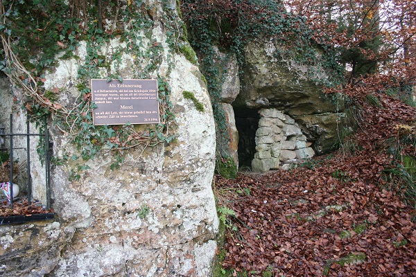
 Hideout in Lintgen;
Credit: David Heal
Hideout in Lintgen;
Credit: David Heal
Chronicle.lu has teamed up with local author and tour guide David Heal of Luxembourg Battles for a new historical series.
Based on David Heal's extensive research spanning several decades (and documented in the form of place-name index cards), the series aims to present interesting local historical events and facts linked to places in (and around) Luxembourg.
Next up is a look at the history of Lintgen. Just a small village on the road to Mersch from the city, one might think, but there is more to it than that.
First of all, its name. According to David's research, this comes from the river. A "Lin" was, in Celtic, a lake or a stretch of water liable to floods. The first mention of it is in a document dating from 896, so long before the city was founded. There used to be several tanneries here, but they have long gone.
Turn up the road to the church (built 1829) and up the valley when one gets past it (a one-way system for part of the way). On the left, one will see ponds on a bend and just after them a turning to the right which has a sign "BUNKER": go up the rough path here until one reaches a sort of four-way junction with a sign saying BUNKER and pointing up a footpath. From the junction, it is a few minutes' walk uphill, finishing with some steps. At the top, one will find a small shrine and beside it a partly built wall with a hole behind it in the rocks. This was a hideout for "réfractaires" (those who refused to be called up to the German army). These can be found all over the country if one keeps one's eyes open (there were over 80 hideouts in all), and some are signposted. Because of the problems of feeding the people hiding in them and the even bigger problems of sanitation, each of them was usually only in use for six to nine months. Here, there is now a plaque giving the names of those hiding here and the people who brought food for them, although David said he found it difficult to believe that only two people were involved in the feeding.
Then go back down to the road and turn uphill for a little way. There is what looks like a fish farm to the left. In fact, although the ponds are full of fish, it is more of a breeding station than a farm. It belongs to the state and, as David explained, the fish are sold to various farms around the country. According to the Food and Agriculture Organization (FAO) of the United Nations, the station typically rears trout imported from Denmark which are then stocked in open fishing waters. Each year, the Water Management Authority releases several thousand fish from Lintgen into the waterways (to replenish fish stocks). David himself has been on a tour of the place but, as it was organised by a friend who knew someone there, he said he was unsure whether it was possible to organise a "public" tour.


