 Credit: LISER
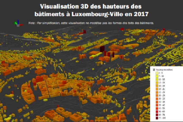
The Luxembourg Institute of Socio Ecomomic-Reasearch (LISER) recently conducted a study to measure the height of buildings in Luxembourg City using LiDAR (Light Detection and Ranging) data.
The rapidly increasing economic and demographic growth experienced in Luxembourg has resulted in significant building needs, with higher units meeded in response to increased residential, industrial and commercial needs. Due to the limited land resources for construction and the need to preserve natural and agricultural areas, densification seems to be an "intelligent solution" to support sustainable urban growth.
In this context, LISER has carried out a first study measuring the height of buildings in the capital automatically using LiDAR data. A first prototype tool named "Lux-SmartGrowth" was developed based on a 'standardised' surface model (MNSn) of high resolution. This was created by carrying out the following operations: by subtracting the influence of the topography on the height of the objects; using a standardised difference vegetation index (also called NDVI) to keep only objects without vegetation; combining the new data with cadastral administrative data to identify the types of buildings. The result of the fusion of these data is a layer of height by type of buildings.
This first study showed that the tool developed has the potential to complement the administrative data of the vertical cadastre by creating an automated 3D cadastre of all buildings with improved accuracy. However, the use of LiDAR data is complex and its application raises many challenges, such as automated feature detection and extraction, manipulation of large amounts of data, LiDAR point classification, and automatic correction of errors in LiDAR data. Nevertheless, the study tackled these various complex aspects and its results showed that the tool was able to quantify, with great precision and a very fine vertical resolution (1m), the heights of all buildings.
The use of such decision-making tools offers valuable assistance to all urban actors toto enrich the administrative data of the cadastre, monitor the heights of buildings and thus estimate their density, create a 3D vertical building survey with detailed roof shapes and precise heights, automatically detect the obstacles that people with reduced mobility and cyclists may face, plan or simulate future densification to accommodate future generations using urban simulation tools and assist in land use planning for more sustainable urban housing management to ensure "smart" city growth.
The Lux-SmartGrowth prototype is still in the development phase. It has been tested on the city of Luxembourg and should soon be extended to the whole country. Eventually, it could be applied to the entire Greater Region.


