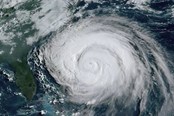
 A satellite image shows Hurricane Erin, the first hurricane of the 2025 Atlantic season, in this screengrab taken from a handout video, over the Atlantic Ocean, Wednesday 20 August 2025;
Credit: Reuters/CSU/CIRA/NOAA
A satellite image shows Hurricane Erin, the first hurricane of the 2025 Atlantic season, in this screengrab taken from a handout video, over the Atlantic Ocean, Wednesday 20 August 2025;
Credit: Reuters/CSU/CIRA/NOAA
(Reuters) - Hurricane Erin, churning north in the Atlantic hundreds of miles offshore, is expected to trigger a dangerous storm surge and tropical storm conditions on Wednesday 20 August 2025, along North Carolina’s Outer Banks and other stretches of the US East Coast.
The National Hurricane Centre warned that roads in the low-lying barrier islands may become impassable, with waves as high as 20 feet crashing ashore. The heavy surf is likely to result in significant beach erosion, it said in its 08:00 EDT (14:00 CET) update.
North Carolina Governor Josh Stein declared a state of emergency on Tuesday 19 August, freeing up state money and manpower to help during the storm and its aftermath.
Tropical storm and storm-surge warnings are in place for other parts of the North Carolina coastline.
Earlier in the week, the coastal counties of Dare and Hyde - which encompass most of the Outer Banks - ordered residents and tourists to evacuate the vulnerable Ocracoke and Hatteras islands, whose populations swell during the summer months.
Local media reported that ferries took more than 2,220 people off Ocracoke, with the final sailing scheduled for 11:00 EDT (05:00 CET) on Wednesday 20 August. Ferries to Hatteras will keep operating as long as conditions allow, ABC News affiliate WCTI reported.
But Chris Styron, manager of the Pony Island Inn on Ocracoke, is ignoring the evacuation orders and staying to watch over the 50-room hotel.
"We're used to storms like this," Styron said. "I'm born and raised here. We're not really worried - it's so far offshore."
The eye of Erin, rated as a Category 2 storm with sustained winds of 100 mph (155 km/h), was expected to move midway between the US East Coast and Bermuda on Wednesday 20 and Thursday 21 August as it travelled northward, the NHC said. That trajectory will keep the worst of its winds offshore.
Tropical-storm-force winds extend up to 265 miles (426 km) from the storm’s centre, with hurricane-force winds extending for 90 miles (140 km).
Even so, the NHC warned beachgoers along most of the East Coast to stay out of the water because of "life-threatening surf and rip currents."
Along the New Jersey shore, swimming and other water activities were prohibited on beaches from Cape May north to Sandy Hook, with high surf and rip current warnings in effect into Friday 22 August, the NWS said. Coastal flooding is expected to peak during high tide on Thursday 21 August.
New York City Mayor Eric Adams ordered all city public beaches - including Coney Island and Brighton Beach - to close Wednesday 20 and Thursday21 August. Fortunately, temperatures in New York were expected to be seasonably cool on Wednesday and Thursday, with highs only reaching 21°C, well below the average of 28°C.
Erin, the fifth named storm of the 2025 Atlantic season and the first to attain hurricane status, had strengthened to a Category 5 storm. The last Atlantic storm to reach that intensity was Hurricane Milton in October 2024.


