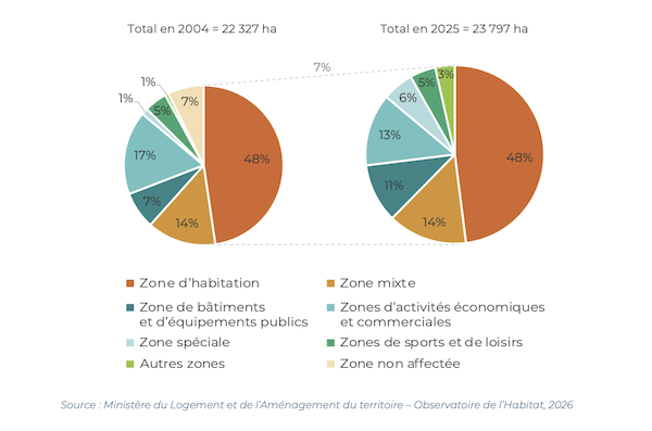
 Allocation of urbanised areas or areas intended for urbanisation in 2004 and 2025;
Credit: Housing Observatory
Allocation of urbanised areas or areas intended for urbanisation in 2004 and 2025;
Credit: Housing Observatory
On Monday 2 March 2026, Luxembourg’s Ministry of Housing and Spatial Planning published the latest analysis from the Housing Observatory, which showed a 7% rise in the development of urban areas between 2004 and 2025.
The Note 45 analysis from the Housing Observatory examined changes in land use, with attention focused on areas intended for residential purposes, in order to provide an understanding of their dynamics and their contribution to the overall evolution of the Luxembourg’s general development plans (PAG). The ministry noted that these trends are also compared with the urban structure that the Master Plan for Spatial Planning (PDAT) utilises, to ensure a more balanced territorial development.
According to the analysis, the proportion of the national territory covered by urbanised areas or areas designated for urbanisation increased from 8.6% in 2004 (22,327 ha) to 9.2% in 2025 (23,797 ha), representing a growth rate of 7%. The overall net increase in urbanised areas or areas designated for urbanisation was 1,470 ha, corresponding to an average net gain of 70 ha per year. 3,253 ha of green areas were converted into urbanised areas or areas designated for urbanisation, while 1,711 ha were reclassified as green areas.
The analysis revealed that the cumulative area of residential zones had increased by 1,082 ha (8%) between 2004 and 2025, reaching 14,839 ha, while the relative share of these areas within the urbanised or designated areas remained stable over the period, at 62% in both 2004 and 2025.
Residential areas (including both purely residential and mixed-use zones) also remained stable, with 87% of the residential areas existing in 2004 retaining this designation in 2025, while conversely, 81% of the residential areas in 2025 had already been dedicated this function in 2004.
The analysis showed that residential dynamics are mainly driven by urban clusters and more than half of the new residential areas are concentrated in the three urban groups - Agglo-Centre, Région Sud, Nordstad - with 40% in endogenous communes and 6% in regional Development and Attraction Centres (CDA) of European and national importance.
The analysis highlighted that endogenous communes contributed significantly to the increase of these new areas due to their large number. The CDAs comprise 26 municipalities where the PDAT anticipates that three-quarters of population growth will be concentrated. The ten CDAs of regional importance, outside of urban clusters, and possessing a certain degree of centrality, are expected to absorb 11.3% of population growth by 2050, whereas the 64 municipalities with endogenous development, and being more rural in nature, are anticipated to receive only a limited share of growth (13.8%).
In terms of overall change, between 2004 and 2025, residential areas remained broadly stable (+8%) and expanded moderately, while other types of zones experienced more significant changes. Areas for buildings and public facilities (+51%, +859 ha), as well as special zones, increased to meet specific collective needs, whereas areas for economic and commercial activities decreased (-18%, -669 ha) to better align with a model of urban development focused on functional mix and the reuse of former industrial sites.
The ministry noted that monitoring these developments is particularly important, as the implementation of national spatial planning guidelines depends largely on decisions made at sectoral and communal levels and said this interdependence called for strengthened coordination among stakeholders to balance general interest and local autonomy.


